
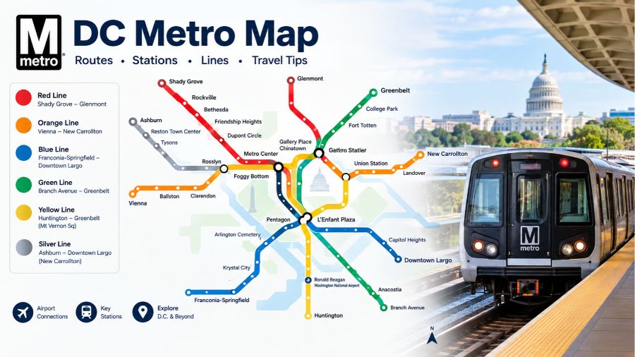
DC Metro Map is an essential travel resource for anyone navigating Washington, D.C., and its surrounding metropolitan areas. It provides a clear overview of the region’s Metrorail network, helping visitors, commuters, students, and residents understand train routes, station connections, transfer points, and airport access. Whether you are planning a sightseeing trip, travelling to work, or visiting popular attractions, understanding the Washington DC Metro map makes public transportation easier to navigate. This guide explains the six Metro lines, important stations, route connections, map features, fares, and practical travel information.
What Is the DC Metro Map?
The DC Metro map is the official route diagram of the Washington Metropolitan Area Transit Authority (WMATA) Metrorail system. It illustrates how six color-coded train lines connect Washington, D.C., with communities across Maryland and Virginia. The map identifies station locations, interchange points, terminal stations, airport connections, and selected accessibility and parking information. It is designed as a simplified transportation guide rather than an exact geographical representation, meaning distances and directions on the diagram may not match real-world locations precisely. The official rail map is updated as the network and station information change, making it important to consult the latest version before travelling.
Understanding the Six DC Metro Lines
The Washington Metrorail network uses six different colors to help passengers identify routes and follow train directions. Each line serves different neighbourhoods, commercial districts, residential communities, and transportation hubs. Some stations are shared by multiple lines, allowing passengers to transfer without leaving the rail network. Understanding these colors and their general routes is the first step towards navigating the DC Metro system confidently.
Red Line
The Red Line connects Shady Grove in Montgomery County, Maryland, with Glenmont, passing through several important communities and central Washington stations. Popular stops include Rockville, North Bethesda, Bethesda, Dupont Circle, Metro Center, Union Station, and Silver Spring. It is particularly useful for travellers visiting downtown Washington, accessing major rail connections, and exploring residential areas north of the capital. Union Station provides an important connection for passengers arriving by intercity train.
Orange Line
The Orange Line operates between Vienna in Virginia and New Carrollton in Maryland. It serves several significant locations, including Dunn Loring, East Falls Church, Ballston, Clarendon, Rosslyn, Metro Center, Smithsonian, L’Enfant Plaza, and New Carrollton. The route is useful for commuters travelling between Northern Virginia, downtown Washington, and Maryland. Passengers can also transfer to other Metro lines at several shared stations along the route.
Blue Line
The Blue Line connects Franconia-Springfield in Virginia with Downtown Largo in Maryland. It serves major destinations such as King Street-Old Town, Crystal City, Pentagon City, Pentagon, Arlington Cemetery, Rosslyn, Foggy Bottom, Metro Center, and Capitol South. This route is particularly helpful for people visiting Arlington, travelling near the Pentagon, or exploring attractions around central Washington. Its connections with the Orange and Silver lines provide additional travel flexibility.
Green Line
The Green Line connects Branch Avenue in Maryland with Greenbelt, serving communities in Prince George’s County and important destinations within Washington. Its stations include Anacostia, Navy Yard-Ballpark, Waterfront, L’Enfant Plaza, Gallery Place-Chinatown, Shaw-Howard University, and Fort Totten. The Navy Yard-Ballpark station is especially useful for visitors attending events around Nationals Park, while Gallery Place provides access to the Chinatown area and several downtown attractions.
Yellow Line
The Yellow Line connects Huntington in Virginia with central Washington and selected northern destinations, depending on the scheduled service pattern. Important stations include King Street-Old Town, Braddock Road, Ronald Reagan Washington National Airport, Pentagon, L’Enfant Plaza, Gallery Place-Chinatown, and Mount Vernon Square. Its airport connection makes it valuable for air travellers, while transfers at Gallery Place and L’Enfant Plaza allow passengers to reach other parts of the network conveniently.
Silver Line
The Silver Line connects Ashburn in Virginia with central Washington and eastern destinations through its shared network sections. It serves important stations such as Washington Dulles International Airport, Loudoun Gateway, Herndon, Reston Town Center, Tysons, McLean, East Falls Church, Rosslyn, and Metro Center. This line is particularly important for travellers using Dulles International Airport and commuters travelling from Northern Virginia. Passengers should check the destination displayed on approaching trains because the Silver Line shares portions of its route with other services.
Important Stations on the Washington DC Metro Map
Certain stations are especially important because they provide connections between multiple lines or access to popular destinations. Metro Center is a major interchange for the Red, Orange, Blue, and Silver lines, making it useful for reaching different parts of downtown Washington. Gallery Place-Chinatown connects the Red, Green, and Yellow lines, while L’Enfant Plaza serves the Green, Yellow, Orange, Silver, and Blue lines. Rosslyn provides connections between the Orange, Silver, and Blue lines. Union Station is another significant location because it connects Metrorail passengers with Amtrak and other regional transportation services. Understanding these interchange stations helps travellers choose routes efficiently and avoid unnecessary transfers.
How to Read and Navigate the DC Metro Map
Reading the DC Metro map becomes easier once you understand its colors, station symbols, and directional labels. Start by identifying your departure station and locating your intended destination. Follow the colored line connecting those stations and check the terminal station name to determine which direction you need. If your destination is on another line, identify a station where the two routes intersect and plan your transfer there. Remember that some stations serve multiple lines, but not every interchange involves the same platform or entrance. The map is schematic, so use the official trip planner to confirm the actual route, travel time, and service information before starting your journey.
DC Metro Map Airport Connections
The Metro network provides convenient rail connections to two major airports serving the Washington metropolitan region. Ronald Reagan Washington National Airport is accessible through the Blue and Yellow lines at the Ronald Reagan Washington National Airport station. Washington Dulles International Airport is connected through the Silver Line, with a dedicated station serving the airport. These connections make public transportation a practical option for many visitors arriving by air. Travellers should still consider luggage, walking distances within airport terminals, train frequency, and any scheduled service disruptions when choosing their airport transportation.
DC Metro Fares and Payment Options
Understanding payment options is just as important as knowing how to read the rail map. WMATA supports SmarTrip cards and contactless payment methods for Metrorail journeys. Passengers can use an eligible contactless credit or debit card, or a supported mobile wallet, through the Tap. Ride. Go. system. SmarTrip remains useful for regular commuters, fare products, and eligible discounted travel programmes. Metrorail fares vary according to factors such as journey distance, travel time, and the day of the week. Passengers must tap their payment method when entering and leaving the rail system, using the same card or device for both actions. Checking the current fare information before travelling helps avoid unexpected expenses.
DC Metro Operating Hours and Train Schedules
Metrorail operating hours vary according to the day of the week and scheduled service arrangements. Weekday, Saturday, and Sunday schedules may differ, and individual lines can experience temporary changes because of maintenance, construction, or operational requirements. Weekend track work can affect station access, train frequency, and normal routes. Passengers should therefore avoid relying exclusively on a printed or downloaded map when planning a journey. Checking current service alerts and the official trip planner provides more reliable information about train arrivals, operating hours, station closures, and replacement shuttle services. This is particularly important when travelling to airports, appointments, or scheduled events.
Benefits of Using the DC Metro Map
The DC Metro map offers several practical advantages for residents and visitors. Its color-coded design makes a large transportation network easier to understand, while clearly marked interchange stations help passengers identify alternative routes. Airport connections support convenient travel between major aviation hubs and the wider metropolitan region. The network also provides access to museums, government buildings, universities, shopping districts, sports venues, and business centres. For tourists, it can reduce dependence on rental cars and make sightseeing more manageable. For regular commuters, understanding the network can simplify daily travel and help identify useful station connections. However, passengers should remember that a route map cannot replace live service information or accessibility details for individual stations.
Limitations and Common DC Metro Travel Challenges
Although the Metro system provides extensive regional coverage, it does not reach every neighbourhood or destination directly. Some journeys require additional bus services, walking, or connections with other regional transportation systems. Maintenance work and unexpected disruptions can also change normal train operations, particularly during weekends. Another common challenge for visitors is identifying the correct train direction, since services are generally identified by their final station rather than only by a compass direction. The system map also does not show exact walking distances between every station and nearby attraction. Checking station information, train destinations, and current travel alerts can help passengers avoid these problems.
Tips for Tourists Using the DC Metro
Tourists can make their Washington, D.C., visit easier by planning journeys around nearby Metro stations. Smithsonian station provides convenient access to the National Mall and several museums, while Woodley Park-Zoo/Adams Morgan serves visitors exploring the National Zoo area. Gallery Place-Chinatown is useful for reaching Chinatown and nearby entertainment destinations. Foggy Bottom-GWU offers access to George Washington University and the surrounding neighbourhood. Visitors should also consider travelling outside the busiest commuting periods when their schedules allow. Keeping a digital copy of the official Metro map and checking real-time service updates can make unfamiliar journeys more straightforward.
The Future of Washington’s Metro Network
The future of the DC Metro system depends on maintaining existing infrastructure, improving reliability, and meeting the transportation needs of a growing metropolitan population. WMATA continues to focus on rail maintenance, station improvements, operational reliability, and customer information services. Digital payment options and updated journey-planning tools are also making the network easier to use. Rather than assuming that every announced improvement represents a completed expansion, passengers should distinguish between active projects, planned work, and services currently operating. The official system map and service announcements remain the most dependable ways to understand the network as it changes.
Conclusion
The DC Metro map is an important resource for understanding public transportation throughout Washington, D.C., Maryland, and Virginia. Its six color-coded lines connect major communities, airports, business districts, government centres, and popular tourist destinations. Learning the main routes, interchange stations, payment methods, and train directions can make travelling around the region considerably easier. However, a successful journey requires more than understanding the printed map: passengers should also check current schedules, fares, and service alerts. By combining the official rail map with real-time travel information, residents and visitors can navigate the Washington metropolitan transportation network more confidently.
Also read: Mbaile: Meaning, Irish Grammar, Pronunciation, and Usage Explained
FAQs
1. Where can I find the official DC Metro map?
The official DC Metro map is available through WMATA’s website, where passengers can view or download the latest Metrorail system map as a PDF.
2. How many lines are on the DC Metro map?
The Washington Metrorail network has six color-coded lines: Red, Orange, Blue, Green, Yellow, and Silver, connecting Washington with Maryland and Virginia.
3. Does the DC Metro go to Dulles International Airport?
Yes, the Silver Line connects Washington Dulles International Airport with the wider Metro network through a dedicated station serving the airport.
4. Which DC Metro station is best for visiting the National Mall?
Smithsonian station is particularly convenient for visiting the National Mall, offering access to major monuments, museums, and popular attractions throughout central Washington.
5. Can tourists pay for DC Metro using contactless cards?
Yes, passengers can use eligible contactless credit or debit cards and supported mobile wallets through WMATA’s Tap. Ride. Go. payment system.
6. Does the DC Metro map show real-time train schedules?
No, the standard system map displays routes and stations rather than live arrivals. Passengers should use WMATA’s trip planner and service alerts for current information.